Norfolk International Airport Maps and Directions
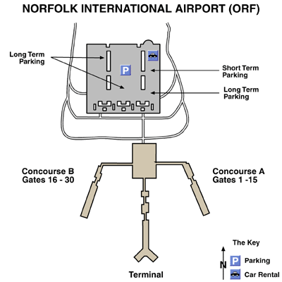
Norfolk International Airport Map
Norfolk Area Map

Maps and Directions
Driving Directions
From North Highway 60
Take a left turn to Highway 170. Turn left again to Azalea Garden Road. Airport Exit is on the left.
From South Highway 166
Take a right turn to into Interstate 64 and then turn right into Highway 192. The Airport Exit is on the right.
From East Highway 13
Travel down to Middleton junction and take Highway 60 and continue to Highway 170. Turn left to Azalea Garden Road. Airport Exit is on the left.
Or
Travel down to Middleton junction and take Highway 166 and continue to Highway 192. The Airport Exit is on the right.
From West Interstate 64
Turn right into Bessie Street down into the Airport Exit on the right.
Featured Hotels