Pensacola Florida Airport Maps and Directions

Maps and Directions
Driving Directions
From Mobile on Interstate 10 or Tallahassee
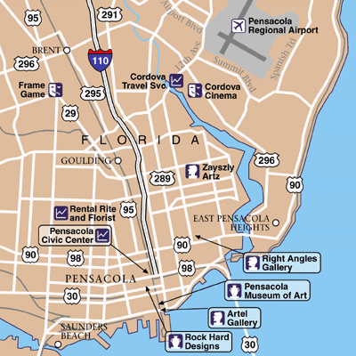
Take Exit #13 (old 5), (Davis Highway/University Mall). Take a left at the traffic light, which is Davis Highway. Proceed to Airport Blvd., past Circuit City and turn left onto Airport Blvd. Arrive at Pensacola Florida Airport.
Due to construction on Davis, use alternate directions
Take Exit 12 (old 4) to Interstate 110 and take the ramp exit to Fairfield. Take a left at the traffic light and stay on Fairfield. Fairfield will turn into 12th Avenue. Pass Bayou and Summit and proceed to the next traffic light, which is Airport Blvd; turn right and arrive at Pensacola Florida Airport. Take the left lane for surface and garage parking. A vehicular security check is mandatory.
From Ft Walton
On highway 98, come into Pensacola and get onto Interstate 110 north. Take exit four onto Fairfield Avenue. Stay on Fairfield. Fairfield changes to 12th Avenue. Stay on 12th Avenue until the intersection of Airport Blvd. Take a right on Airport Blvd into terminal or after coming across the bridge from Gulf Breeze, stay in the right lane onto Gregory Street and turn right on Ninth Avenue. Go three miles up to Fairfield and turn right. At the Fourth Street traffic light is Airport Blvd. Turn right and arrive at Pensacola Florida Airport.
Highway 10 from the East
On Interstate 10 take Exit 17 to Scenic Highway, take a right on Langley Avenue. Turn left on Tippen Avenue and continue until 12th Avenue and Airport Blvd. On Airport Blvd turn left and arrive at
From Gulf Shores and Orange Beach
On Highway 98 to Fairfield Drive (727) turn left on Fairfield; stay on Fairfield and turn into 12th Avenue. Turn right on Airport Blvd and arrive at
From Foley
On highway 98, turn left onto Blue Angel Parkway. Take Blue Angel Parkway to Saufley Field Road. Turn right onto Saufley Field Road and continue on this road (disregard change of road name). At the 12th Avenue traffic light turn left onto 12th Avenue. Continue on for two more traffic lights - the second light is Airport Boulevard. Turn right and arrive at Pensacola Florida Airport.


